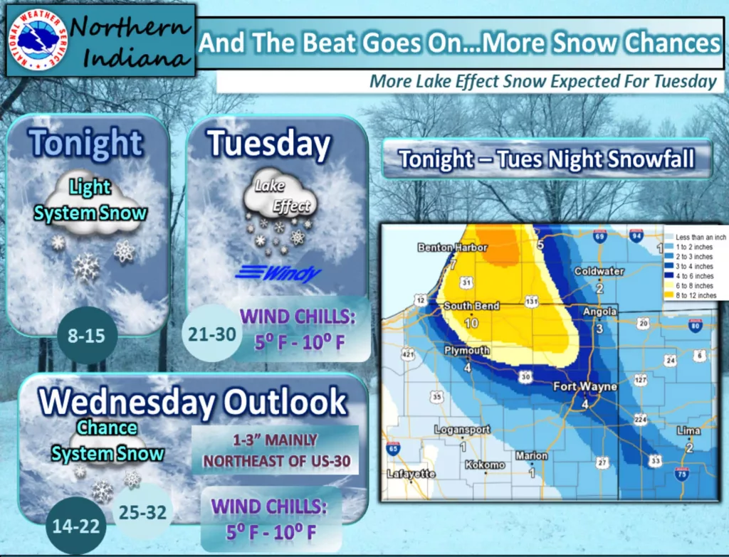
Looks like our Friday and Saturday blitz of snow was just the beginning. The National Weather Service has upgraded what had been tabbed as a Winter Storm Watch into a Winter Storm Warning for Berrien and Cass Counties in SW Michigan. The snow doesn’t get underway in earnest until early tomorrow, Tuesday, morning, but then it could turn into a major deal depending on how the lake effect snow bands set up.
Here’s with the Northwest Indiana office of the National Weather Service is showcasing:
…WINTER STORM WARNING IN EFFECT FROM 1 AM TUESDAY TO 7 AM EST
WEDNESDAY…
* WHAT…Heavy lake effect snow possible. Plan on difficult travel
conditions, including during the morning and evening commute on
Tuesday. Total snow accumulations of 5 to 9 inches, with
localized amounts up to 12 inches, are possible. Blowing and
drifting snow also possible with strong and gusty northwest
winds.
* WHERE…In Indiana, St. Joseph IN and Elkhart Counties. In
Michigan, Berrien and Cass MI Counties.
* WHEN…From 1 AM Tuesday to 7 AM EST Wednesday.
* ADDITIONAL DETAILS…Winds gusting between 30 and 40 mph will
cause areas of blowing and drifting snow making travel
difficult, especially on east west roads. Snowfall rates of 1 to
3 inches per hour will be possible within the stronger lake
effect bands. Whiteout conditions will likely occur in these
bands.
PRECAUTIONARY/PREPAREDNESS ACTIONS…
A Winter Storm Warning for heavy lake effect snow means
significant amounts of lake effect snow are forecast that will
make travel very hazardous or impossible. If you must travel,
keep an extra flashlight, food, and water in your vehicle in case
of an emergency. The latest road conditions for the state you are
calling from can be obtained by calling 5 1 1.