While Mother Nature played nice for most shoppers across the Midwest as they ventured into the stores either late in the day on Thanksgiving, throughout Black Friday, into Small Business Saturday and even here as we wrap up the holiday weekend, she’s decided that we need things to look a lot more like Christmas, apparently.
The National Weather Service in Northern Indiana rolled out of the sack extra early this morning to issue a Winter Weather Advisory at 3:39am this morning, warning that by the end of the day tomorrow, Monday, November 26th, we could have up to five fresh inches of snow on the drive.
The “Urgent Winter Weather Message” was released well before dawn and doesn’t actually go into effect until midnight tonight. It is expected to remain in effect until 1pm tomorrow afternoon, so it looks to be a fairly swiftly moving system, delivering the snowy, icy punch.
Those Counties impacted by the Winter Weather Advisory include:
- LaPorte County, Indiana
- St. Joseph County, Indiana
- Berrien County, Michigan
- Cass County, Michigan
- St. Joseph County, Michigan
It also includes the following communities:
- Michigan City
- LaPorte
- South Bend
- Mishawaka
- New Carlisle
- Walkerton
- Niles
- Benton Harbor
- St. Joseph
- Fairplain
- Benton Heights
- Buchanan
- Paw Paw Lake
- Dowagiac
- Cassopolis
- Marcellus
- Sturgis
- Three Rivers
- White Pigeon
- Mendon
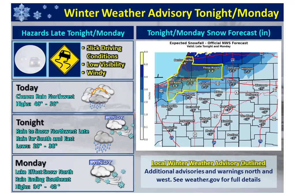
Here’s what they are forecasting:
WINTER WEATHER ADVISORY IN EFFECT FROM MIDNIGHT EST /11 PM
CST/ TONIGHT TO 1 PM EST /NOON CST/ MONDAY…
* WHAT…Snow expected. Total snow accumulations of 2 to 5 inches
expected with the highest amounts across northern Berrien and
Cass Counties. Winds gusting as high as 45 mph along the
lakeshore with gusts up to 35 mph away from the lake.
* WHERE…In Indiana, La Porte and St. Joseph Counties. In
Michigan, Berrien, Cass and St. Joseph MI Counties.
* WHEN…From midnight EST /11 PM CST/ tonight to 1 PM EST /noon
CST/ Monday.
* ADDITIONAL DETAILS…Plan on slippery road conditions. The
hazardous conditions could impact the morning commute.
PRECAUTIONARY/PREPAREDNESS ACTIONS…
A Winter Weather Advisory for snow means periods of snow will
cause primarily travel difficulties. Expect snow covered roads
and limited visibilities, and use caution while driving. Strong
winds will also make driving difficult…especially for high
profile vehicles.
Be prepared for the worst possible scenario in order to best handle whatever gets thrown our way. Stay tuned for additional details as we draw closer to the advisory time period.