If you’re feeling parched following day-after-day forecasts of 90+ degree weather and virtually no rain to speak of, just imagine how the crops in Michigan’s fields, farms and orchards are handling things. According to the Michigan Farm Bureau the answer is not what you want to hear.
While farmers across the Lower Peninsula experienced a much better spring for planting and growing conditions this year than in 2019, once summer officially started on June 20th, the rains dried up and the mercury headed north of 90 degrees for days on end.
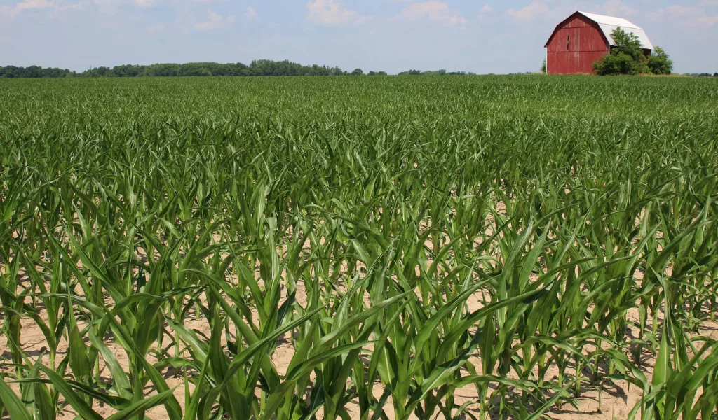
Later planted crops with shorter root systems and crops on lighter soils are showing signs of stress, as shown in the photo accompanying this story on Moody on the Market, where a field of corn is beginning to show leaf curling. Photo credit goes to the Michigan Farm News.
In some areas of the state, the heat and lack of rain are beginning to take a heavy toll on potential yields that are being compromised each day. Farm authorities say that with little chance of rain predicted in the extended weather forecast – the losses could mount quickly.
One of the first crops to be harvested is wheat. The hot and dry conditions have sped up maturity, and combines have begun to roll in areas of the state. Michigan Farm Bureau Commodity Specialist Theresa Sisung indicates quality appears to be good coming out of the field, and yields are okay.
Sisung reports, “Wheat yields have definitely been impacted by hot and dry weather during the end of grain fill,” and adds, “The heat has helped crops to catch up in development after a cooler spring. Growing degree days were behind normal across almost all of the state but now the majority of Michigan is slightly above normal.”
According to Sisung, corn and soybeans on heavier soils can draw subsoil moisture but leaf rolling and turning are becoming commonplace. Topsoil moisture has declined dramatically over the past three weeks, with daily evaporation rates reaching a quarter inch or more. That means plants are relying on subsoil moisture to continue growing or even just to survive.
Heavier dews have helped to hold off some of the stress and allowed plants to recover somewhat. Unfortunately, with overnight temps predicted to stay warm over the next several days, there is less chance of a heavy dew.
Rob Rudat is the Agronomy Manager at County Dairy Inc. in the community of New Era in Oceana County. He oversees 2,000 acres of corn, 750 acres of alfalfa, with the remaining being wheat, rye and oats, all grown on lighter, sandy soil.
Rudat says, “The last 16 days here have been at or above 90 degrees and without any rain,” adding, “Our wheat was hit with a late frost, but luckily we escaped any major issues. And though we expect somewhat normal yields, we’re seeing lower test weights due to that lack of moisture that makes for smaller kernels.
Rudat goes on to note, “Because we’re on sandy soils, irrigators are running, putting down three to four-tenths of an inch of water on our corn and alfalfa daily. But even with that, we’re seeing shorter corn stalks and expecting smaller ears. And when it comes to the alfalfa, we’re probably not going to get a fifth cutting this year.”
Sixty miles south of New Era, Jeff Russcher raises corn, soybeans, and hogs on his multi-generational family farm near Zeeland in Allegan County. His crops are grown on what he refers to as medium soil.
Russcher complains, “It’s been 10 days since we’ve had any rain worth mentioning, and the heat is sucking the moisture out of the ground at a rapid speed,” and suggesting, “Because of some hard pounding rains we received in May, we got a bit of late start on planting, finishing up on June 8th. So, corn pollination is going to be delayed a bit. Hopefully, the rain will come and the heat will subside.”
Based on MSU EnviroWeather models, corn pollination should begin in 10 days or so. And while it has been hot and dry, according to the US Drought Monitor map of July 2nd, nearly 95-percent of Michigan is not considered to be in a drought, as of yet. A new map is due to be released tomorrow, Thursday, July 9th.
Unfortunately, Michigan State University Extension Agricultural Meteorologist, Jeff Andresen, says most current medium-range forecast guidance calls for a general continuation of the central U.S. ridging upper air pattern that is responsible for the current weather pattern to continue into the second half of July.
Andresen advises, “The NOAA Climate Prediction Center revised monthly outlook for July now calls for warmer- and drier-than-normal weather in much of Michigan,” and warns, “Further ahead, the new NOAA long-lead outlook for the July through September period is calling for warmer-than-normal mean temperatures. Similar to the July outlook, it also has backed off on precipitation totals, with mostly equal chances for below-, near-, and above-normal totals.”
That’s not the news farmers want to hear right now says Sisung, who concludes, “We really need some rain and a break from the hot temperatures prior to corn pollination otherwise the negative impact on yield could be substantial.”