As the world of business and government management becomes increasingly data driven, it comes as no surprise that companies like Benton Harbor-based Wightman & Associates are being tapped more and more for services by their GIS Department. As a result, the company has expanded the GIS team with several new hires.
The company’s recent notable growth serving clients throughout southwest Michigan and other parts of the state with data driven services brings four new GIS experts to the team.
GIS, which stands for Geographic Information Systems, is the software used for capturing, managing, analyzing, and displaying location-based data. GIS can “layer” other types of data, allowing users to see patterns and relationships. It supplies decision makers with easy-to-access spatial data anywhere, anytime, on any device.
According to WAI GIS Manager Ryan Miller, the growth in this sector of the company’s service line has been primarily a result of increased involvement with municipalities applying for and implementing work related to Stormwater Asset Management & Wastewater (SAW) grants. Awarded by the State of Michigan, SAW provides communities with funds to inventory and assess the condition of their sewer and stormwater systems. Long-term master plans for system upkeep, replacement, and expansion are developed through the program.
In recent months, the company has begun assisting 10 additional communities with SAW grant projects, bringing the total number municipalities WAI is working with in this capacity to nearly 30.
Miller tells us, “Each project takes up to three years to complete and requires experts in GIS mapping and analysis to lead the work. To deliver continued exceptional service to our clients, we have expanded our team with the addition of several newly hired GIS professionals.”
Miller goes on to say that a variety of other projects have added to the need to grow the department. By 2018, many municipalities will be required by the State of Michigan to develop water system asset management plans. WAI is helping several of its clients prepare for this mandate through the use of GIS technology. The team is also showing municipalities how to capitalize on the broader potential of the GIS software they have as a result of SAW grants.
Miller points out that communities can use GIS platforms, “To proactively manage other municipal assets and capitalize on the reduced price of the software purchase through the grant.” He adds, “We are working with many of our clients to implement maintenance systems that will provide a tool to document work performed, schedule preventative maintenance, and create simple reports. WAI is involved in developing GIS data-driven, long-term capital planning models so they can be financially ready when it is time to replace or expand municipal assets.”
GIS is also used within the company to support its recently added Planning services delivered by WAI’s Architectural Studio and Engineering Teams.
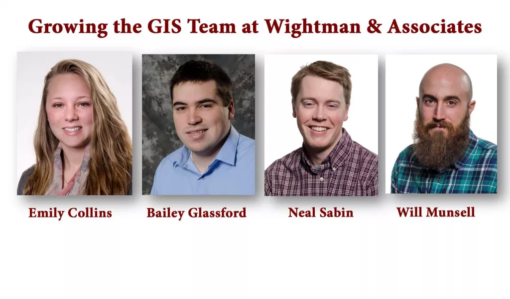
The four professionals who have recently joined the department to assist GIS service delivery to clients include:
- Emily Collins of Rochester Hills, who has been hired as a GIS technician based out of WAI’s Portage office. She holds a Master of Geographic Information Systems degree and a Bachelor of Science degree in Applied Ecology and Environmental Science, both from Michigan Technical University. She is experienced in using a variety of GIS database and modeling software programs and has worked as a wildlife technician for the United States Forest Service and MTU.
- Bailey Glassford of Ann Arbor joins WAI as a GIS technician in its Portage office. He is a graduate of the University of Michigan – Dearborn with a Bachelor of Science degree in Earth Sciences/Geosciences and holds a GIS certificate. Glassford has worked as a GIS lab proctor at the university instructing new students on the use of GIS software. He has extensive knowledge of North American geology, ArcGIS software, and holds a 40-hour Hazardous Waste Operations and Emergency Response certificate.
- William Munsell of Portsmouth, Virginia, joins the WAI team as a GIS analyst/programmer based out of the company’s Portage office. He has six years of experience as a GIS technician and senior geospatial analyst, with background in geodatabase design and development; data collection, consolidation, and analysis; cartographical map design; integration of AutoCAD and GIS; and automation of geoprocessing workflows. He holds a Bachelor of Science degree in Software Development and Associate of Science degree in Database Programming from ECPI University in Virginia Beach, and GIS certification from Tidewater Community College, also in Virginia Beach.
- Neal Sabin of Gladstone, Michigan, has been hired as a GIS technician based in the WAI Benton Harbor office. Sabin holds a bachelor’s degree from Northern Michigan University with a major in Geomatics and a minor in Integrative Science and Biology. He previously worked as a GIS/CAD technician as part of Northern Michigan University’s Engineering and Planning Department where he created landscape and utility maps, collected and managed spatial information, and developed interactive maps.
To learn more about GIS services provided by Wightman & Associates, Inc., you can call 269-927-0100 or visit www.wightman-assoc.com.
Wightman & Associates, Inc. is a civil engineering, architectural, environmental and survey firm that has been serving Southwest Michigan and Northern Indiana since 1946 with offices in Benton Harbor, Portage, and Allegan, Michigan.


