The jaw-dropping power of Mother Nature in the past week has been nothing short of catastrophic for the Lake Michigan shoreline and many beaches both major and minor in Michigan’s Great Southwest. Sadly, the worst may be yet to come.
The National Weather Service office in Grand Rapids says that what’s headed into the region today and all the way into tomorrow night, October 21st and 22nd, has the potential to be even worse than last week’s juggernaut that scooped out huge chunks of shoreline in seemingly unprecedented ways.
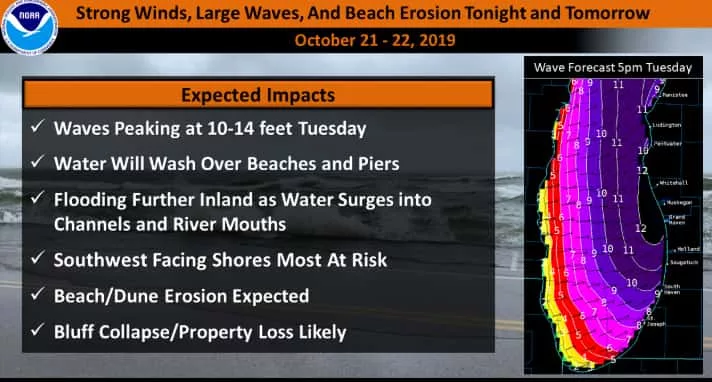
Here’s what the NWS office in Grand Rapids says today:
“Details are now coming into focus for another round of lakeshore flooding and beach erosion beginning tonight and lasting into Tuesday night. This event has the potential to be a bit worse that the event last week in terms of damage due to the winds being more onshore and of longer duration. Southwest to west winds of 35 to 45 mph will build waves into the 6 to 10 foot range tonight. Waves will peak at 10-14 feet Tuesday afternoon and evening.
The already high Great Lakes water levels combined with a storm rise of 1 to possibly 2 feet and large battering waves on top of that will lead to beach and dune erosion. Lakeshore flooding of low lying areas is likely as water pushes up and over beaches in some spots and through the pier heads and into river mouths. In the event last week we saw sidewalks, roads and docks become submerged in beach towns. Steer clear of the piers on Tuesday as large waves will be overtopping them.”
Social media was filled with photos of massive erosion, flooded streets, docks, rivers, piers and beyond all weekend long, and now comes word of more devastation potentially waiting in the wings. Be prepared, and stay away from the piers, breakwaters and other dangerous places long the Lake Michigan shore throughout the posted storm periods.