
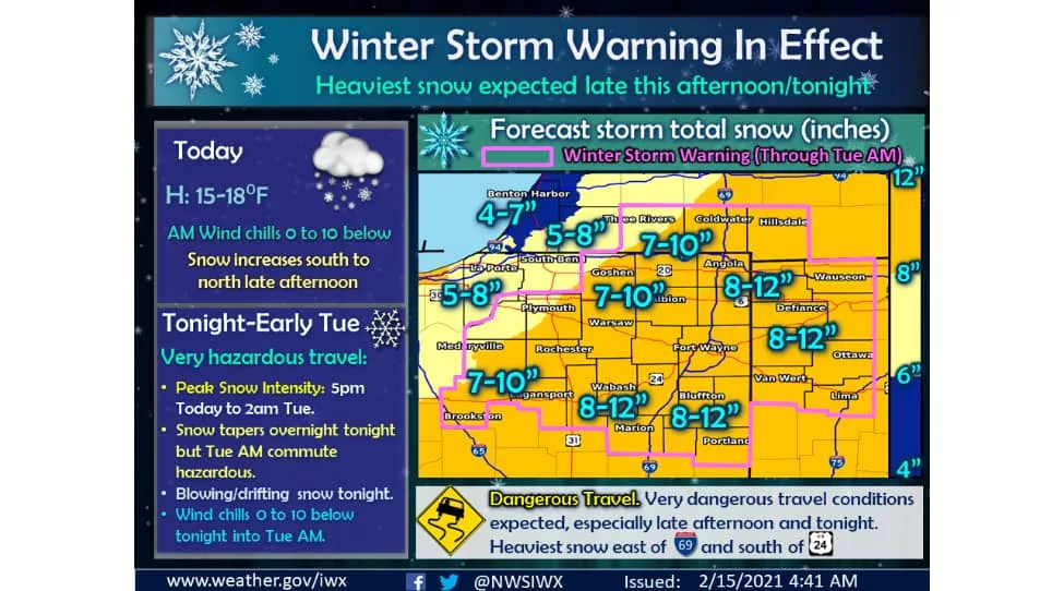
What had been a Winter Weather Advisory for Berrien County has now become a Winter Storm Warning, with the potential for anywhere from 4 to 10-inches of new snow falling on the region by 10am tomorrow morning, Tuesday, February 16th.
The National Weather Service office in Northwest Indiana says that the light snow of this morning, turned into a brief lull this afternoon, but we should expect an entirely different picture tonight. They report that an area of heavy snow is expected to lift northward across the region late this afternoon into tonight, with snowfall rates of 1 to 2 inches per hour possible this evening. Storm total snow accumulations of 6 to 12 inches are expected in the winter storm warning area with the highest amounts generally east of Interstate 69 and south of US Route 24.
In addition, some blowing and drifting snow will develop tonight as north winds strengthen to 15 to 20 mph with some gusts to 25 mph. Winter Storm Warnings are in effect for the area outlined in pink in the map photo accompanying this story, but what had been Winter Weather Advisories outside of those lines have been added into the Winter Storm Warning as of 2:15 pm this afternoon, including the region of Southwest Lower Michigan.
In the message adding Berrien and Cass Counties into the Winter Storm Warning, officials said, “Snow will continue to increase in coverage and intensity, peaking this evening when snowfall rates of an inch or more per hour are expected. The majority of the snow will fall between 7 pm this evening and 2 am Tuesday. Gusty winds will cause blowing and drifting snow, mainly in rural areas. Additional accumulations of 5 to 8 inches are expected by the time the snow tapers off Tuesday morning. Wind chills overnight into Tuesday morning will range from 10 below to zero.”
National Weather forecasters say, “Snow will taper off overnight tonight, but the Tuesday morning commute will likely be very hazardous due to snow covered roads.” On top of that, they tell us that looking ahead, another system may bring some significant snowfall to the region by late Wednesday into Thursday. Stay tuned.