
The National Weather Service is warning about what could be the first major storm of the winter season for Michigan’s Great Southwest as we head into the weekend. Michigan State Police are also joining the efforts to keep everyone safe from the potential impact.
The National Weather Service office in Northwest Indiana says they are continuing to monitor the developing winter storm expected to sweep across the Midwest this weekend. They report that snow is expected to start late tomorrow night, Friday, January 18th, and continue into late Saturday night.
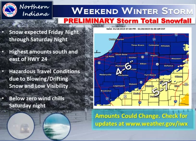
Meteorologists say that the current forecast models continue to shift the track of the system which has significant impacts on snow amounts. As a result they say we can expect forecast snow amounts to change with time and everyone should check for forecast updates. At this point, forecast snow totals of 4 to 6 inches are possible for locations north and west of US Highway 24, including all of Berrien County, and 5 to 7 inches are possible south and east of US Highway 24 into Northwest Indiana.
Authorities are suggesting that if you are planning on traveling this weekend you need to be aware that breezy northeast winds of 20 to 25 mph will cause lowered visibility and drifting snow, and that might make it more difficult for plow crews to keep roadways cleared; especially on east-west roadways. Saturday night will also see wind chill values drop below zero.
As a result of current forecast conditions, the National Weather Service has issued a Storm Watch which will go into effect Friday evening and continue through Saturday evening at this juncture.
Here’s the balance of their watch notice:
Heavy snow possible along with gusty winds and significant blowing and drifting snow.
Total snow accumulations of 4 to 7 inches expected, with locally higher amounts possible.
Portions of Northern Indiana and Southwest Michigan.
From Friday evening through Saturday evening.
Snow overspreading the area Friday evening through late Friday night and continuing into Saturday afternoon.
Moderate to heavy snow combined with gusty northeast winds to 25 to 35 mph on Saturday into early Saturday evening will create hazardous travel conditions.
A Winter Storm Watch means there is potential for significant snow, sleet or ice accumulations that may impact travel.
Continue to monitor the latest forecasts.
Meanwhile, the Michigan State Police have issued a set of cautionary guidelines for dealing with the upcoming weather.
They say that with frigid temperatures expected to impact the entire state beginning this weekend, they are encouraging residents and visitors to be extra cautious when going out in the extreme cold.
Capt. Emmitt McGowan is Deputy State Director of Emergency Management & Homeland Security as well as Commander of the Michigan State Police Emergency Management & Homeland Security Division. he says, “Extremely cold temperatures can be hazardous and potentially life-threatening.” McGowan adds, “We are asking that Michiganders monitor their local weather reports and follow the appropriate steps to stay safe during this cold spell.”
State Police reiterated the National Weather Service forecast for wind chills potentially causing temperatures to fall below zero at times Saturday night through Monday morning in the Lower Peninsula. Parts of the Upper Peninsula will experience below zero overnight temperatures through next weekend. Exposure to these temperatures could potentially cause frostbite and hypothermia, as well as create hazardous driving conditions.
To stay safe during cold weather Michigan State Police suggest that you:
- Stay indoors if possible. If you must go outside, wear protective gear, such as hats, mittens, gloves, scarf and a warm coat.
- Avoid overexertion when shoveling heavy snow, pushing a car, or walking in deep snow. Take breaks frequently.
- Watch for signs of frostbite, which include loss of feeling or pale appearance of fingers, toes or face.
- Watch for signs of hypothermia, which include uncontrollable shivering, memory loss, drowsiness and exhaustion.
- Understand the hazards of wind chill. As wind speed increases, heat is carried away from a person’s body more rapidly and could lead to severe hypothermia.
- Remove clothing if it gets damp or wet. Wet clothing can make you more prone to hypothermia.
- Weatherproof doors and windows to trap heat inside your home.
- Check heating units. Poorly operating or damaged heating units can release carbon monoxide gas.
- Test carbon monoxide detectors for proper operation and battery life.
- Check on family, friends and neighbors who are at risk and may need additional assistance.
- Watch pets closely and keep them indoors when possible. Animals can suffer from hypothermia, frostbite and other cold weather injuries.
- If travel is necessary, keep a full tank of gas and an emergency preparedness kit in your vehicle. Put warm clothing, such as gloves, blankets and hats, and a cell phone charger in your kit.
Michigan weather is unpredictable any time of year, but especially during the winter months. If you are stranded, do not leave your vehicle. Stay with the vehicle and wait for help.
Motorists are encouraged to check travel conditions and weather reports before driving at www.michigan.gov/roadconditions. Major road closures can be found at www.michigan.gov/drive. The MSP/EMHSD asks that you tune into local news and/or view these websites rather than calling your local MSP post or 911 for travel conditions.
Residents who need assistance or guidance during the extreme cold are encouraged to call 211.
For more information on how to prepare before, during and after an emergency or disaster, visit www.michigan.gov/miready or follow MSP/EMHSD on Twitter at @MichEMHS.